Racially Restrictive Covenants, Modesto, CA
After the Great Depression prompted the National Mortgage Crisis of the 1930s, legislation from the New Deal provided a shift on mortgage lending. The Federal Government backed mortgage lending not just as a path to increase homeownership but also wealth accumulation. However, not everybody was treated equally. Non-white communities were redlined and housing developments and housing deeds on those developments started to add Racially Restrictive Covenants with a similar language to this:
“H) That said lots, or any portion thereof, shall not be used in any manner whatsoever or occupied by any Negro, Chinese, Japanese, Hindu, Malayan, Mexican, Cuban, or native of the Turkish Empire, or any person not of the Caucasian race, or descent thereof except as the servant of the occupant.”
These Racially Restrictives Covenants were used across the United States and Modesto was not an exception. These records show how RRCs were used in Modesto mainly around the 1930s, 1940s, and 1950s. Although these restrictions are not applicable nowadays, their effects continue haunting the deepest fabric of our society.
USE LIMITATIONS:
This web mapping application is a resource for General Information. The California State University, Stanislaus and CASA, the Center for Applied Spatial Analysis, delivers this information with the understanding that it is not guaranteed to be accurate or correct. This project has not concluded but is under continuous assessment and new data will be added as we uncover more information. Therefore, any conclusions drawn from such information are the sole responsibility of the user.
The California State University, Stanislaus and CASA, the Center for Applied Spatial Analysis, shall assume no liability for: errors, omissions, inaccuracies in the information and any decision made or action taken by the user in reliance upon any information.
The use of this web mapping application indicates your unconditional acceptance of this disclaimer.
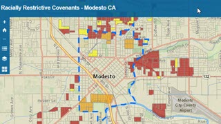
Web Mapping Application
Go directly to the web mapping application and examine what areas in Modesto were under racially restrictive covenants.
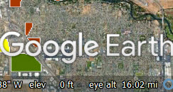
Layer (KML format)
Download the layer in KML format for Google Earth. Please, download the instructions to use this KML layer in Google Earth.

Layer in GDB format
Download the GDB file. You can use it in Arc GIS Pro to examine areas under racially restrictive covenants.
Racially Restrictive Covenants
Digital Project Sponsors
Sharon Froba | Sharon Froba founded Modesto High School’s annual Day of Respect in 1998. Day of Respect has been featured on Inside California Education, a show on PBS, KVIE Channel 6, and the Modesto Bee. As a retired teacher, Sharon has continued working for our community. Sharon and David took on the painstakingly difficult task of collecting and identifying documents from the Stanislaus County archives on Racially Restrictive Covenants in Modesto.
David Froba | As a retired attorney at law, David Froba has helped uncover over one hundred subdivisions, and counting, with racially restrictive covenants (RRC's) In Modesto. RRC's were used as a legal tool to segregate many cities across the United States, and Modesto was no exception. These records show how RRCs were used in Modesto mainly around the 1930s, 1940s, and 1950s.
David and Sharon Froba have sponsored this project in addition to facilitate the data for this work.
Digital Project Team
Cameron Pallotta | He is lecturer in the Geography Program and the Geography GIS computer lab manager at California State University, Stanislaus. He worked as a GIS Analyst for more than 10 years, helping to develop GIS systems for agencies in the Central Valley of California.
José R. Díaz-Garayúa | He is Associate Professor of Human Geography and Geographic Information Systems (GIS) at California State University Stanislaus. He is co-Director of CASA, the Center for Applied Spatial Analysis. His research focuses on inequities with emphasis on race, ethnicity, and place. One of his interests spin around the intersection of Geography (Geographic Thought, Spatial Thinking, and GIS) and the Humanities (particularly the human experience and cultural studies).
Updated: July 06, 2023